
Roseburg ZIP Code Coverage
Roseburg has two documented delivery ZIP codes: 97470 and 97471. The U.S. Postal Service Office of Inspector General reported in June 2026 that the Roseburg Main Post Office serves about 51,134 people across those delivery areas. That count describes a postal service area, not the City of Roseburg. The Census reports 23,683 people in the incorporated city in 2020, so a ZIP code directory needs to keep postal and municipal geography separate.
| ZIP | Supported delivery relationship | Post office note | Research limit |
|---|---|---|---|
| 97470 | Roseburg downtown and Main Post Office postal address; part of the Roseburg MPO service area. | Roseburg Post Office, 519 SE Kane St, Roseburg OR 97470-4965; 541-673-3620. | Its service area is larger than, and not equal to, the incorporated city. |
| 97471 | Part of the Roseburg MPO service area; county property examples include Roseburg OR 97471. | Created for the Roseburg Carrier Annex delivery area in 2008. | Its exact boundary requires a USPS lookup using the actual address. |
The Census city profile supplies the municipal population context shown in the image below.
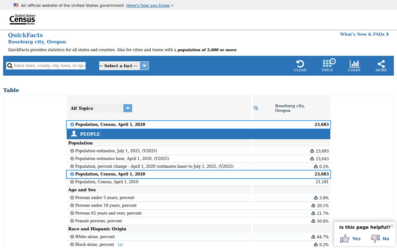
The different counts are not competing estimates. They describe different geographic units, which is why a Roseburg ZIP code should never be treated as a city-limits map.
Roseburg ZIP Code Service Area
The USPS Office of Inspector General report establishes the current Roseburg Main Post Office service-area context for 97470 and 97471. It does not identify a person, establish a home address, or redraw the city line. Use it to understand why a Roseburg mailing address can extend beyond the incorporated city and why a postal ZIP alone cannot resolve planning, voting, assessment, or legal land questions.
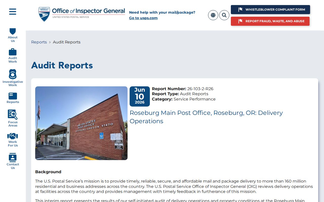
The audit is especially helpful when comparing Roseburg city figures with a broader postal-area reference. It supports the two-ZIP scope, not a neighborhood-by-neighborhood boundary claim.
Postal service and county records serve different jobs. USPS assigns or confirms mail delivery for an address. Douglas County Assessor and GIS records describe parcel, map, situs, and jurisdiction information. The County Clerk records a legal land identity and instruments. Keeping those functions separate avoids turning a mailing code into evidence it cannot provide.
Roseburg ZIP Code Shift
A dated address trail needs one local warning: 97471 was established in 2008 for a Roseburg Carrier Annex delivery area. The Postal Bulletin says 12,730 deliveries that had used 97470 were moved to the new ZIP code. A historical document carrying 97470 can therefore concern a property whose present mailing ZIP is 97471. The code difference by itself does not show a physical move, a new parcel, or a city-boundary change.
The 2008 USPS Postal Bulletin is the documented source for the delivery realignment.
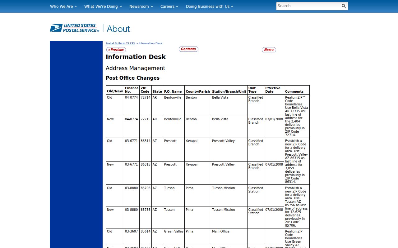
When an old deed, directory, envelope, or newspaper notice uses 97470, record its date before trying to reconcile it with a current address. The parcel’s legal description and historic maps are sturdier links across a code change.
Note: A postal update may change a mailing ZIP while leaving the physical street address and recorded land description unchanged.
Find Roseburg Residents by ZIP
A ZIP code narrows an address question, but the researched Douglas County forms do not provide a verified public five-digit ZIP filter for an area-wide resident search. The Assessor’s combined public search accepts an address, tax lot, or property identifier. GIS offers Find Address and Find Parcel functions. The voter list is request-driven under Oregon law, with geography limited by agency capability. Rather than imply a dropdown exists, use the ZIP as an address-verification step and then use the appropriate parcel, road, or records channel.
- Enter a complete street address, city, and state in the USPS ZIP Lookup and save the standardized result.
- Enter the same physical address or a partial address in the Douglas County Assessor or GIS system.
- Separate the USPS mailing code from the parcel’s situs, map or tax lot, and legal description.
- Use the County Street Directory or GIS Find Road to normalize a road name before deed research.
- For a broader public-records question, ask Douglas County or the Oregon Secretary of State whether a formal request can be geographically limited.
Once an address is narrowed to a named road, the Roseburg street directory has the fuller address-to-parcel and recorded-document workflow. USPS warns that a ZIP result does not confirm a person or company is at the address, so it should not be used as proof of residency.
Roseburg ZIP Code Search Fields
USPS provides the verified ZIP-capable form in the local research set. Its address lookup uses an actual street address with city and state to determine the ZIP. This is an address-to-ZIP check, not a name search. The table also records the county tools that may follow it, including their documented limits. No source examined here verifies a five-digit ZIP filter in the Assessor, GIS, or voter public forms.
| USPS street address | Enter the actual street address with city and state to determine the mailing ZIP for that address. |
|---|---|
| Assessor combined search | Use address, tax lot, or property identifier. The researched public form does not show a ZIP-only filter. |
| GIS Find Address or Parcel | Use an address, parcel name, ID, or map tax lot as supported by the GIS help; no ZIP-only filter was verified. |
| Voter-list request | Use Oregon’s formal request route. It is not a casual public name-by-ZIP browser, and available geography depends on agency capability. |
USPS Roseburg Post Office details identify the 97470 Main Post Office location shown here.
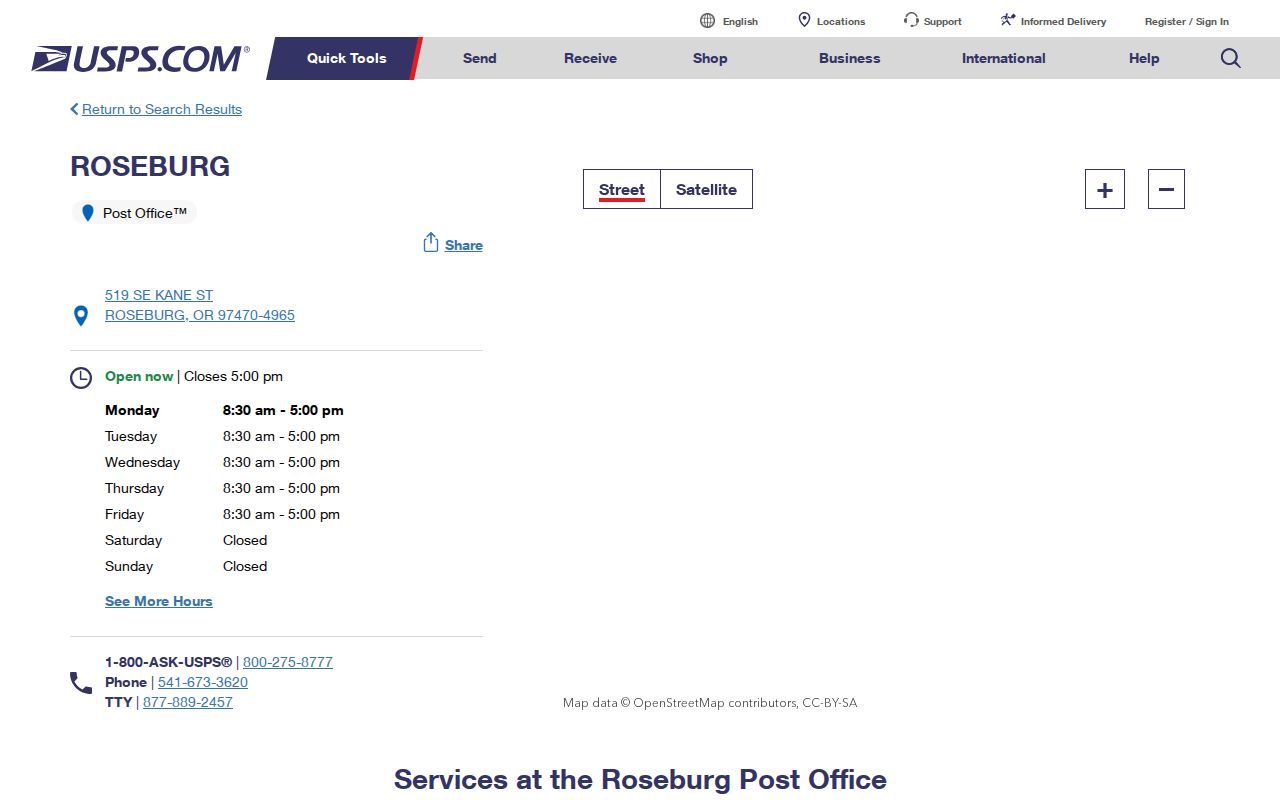
The post office listing supports the local 97470 office reference. Use the separate USPS lookup form, not a general post-office listing, to check a particular delivery address.
Roseburg ZIP Codes and Limits
Roseburg ZIP codes do not define Roseburg city limits. A Roseburg postal city or a 97470 or 97471 code may cover an address outside the incorporated city. The 2024 Charter Oaks urban-growth-boundary action gives a local example of overlapping geographies: some property can be within the urban growth boundary without being annexed, while City and County approvals can divide authority. USPS resolves mail delivery; Assessor and GIS tools are the checks for parcel and city-boundary questions.
- ZIP code
- A postal delivery code for an address or service area. It is not a municipal boundary.
- ZIP+4
- An added four-digit postal segment that helps sort delivery more precisely within a ZIP code.
- PO-box ZIP
- A code assigned for post-office boxes. Research found no basis to describe 97471 as a PO-box-only ZIP.
- Unique ZIP
- A code assigned to one organization or institution. Research found no basis to describe either documented Roseburg ZIP this way.
- Carrier route
- A postal delivery grouping. The 2008 97471 change involved a Roseburg Carrier Annex delivery area.
Roseburg Situs and Mailing Geography
Local property records use several address concepts. A situs or physical address is the location of the land or building on the Assessor record. A mailing address is where the owner-information section sends correspondence and can be a post-office box or another city. A legal description is the land identity recorded through a prior instrument or book and page, lot and block, subdivision, metes and bounds, or partition parcel. A property ID, account, map, or tax lot is a county retrieval key, not a substitute legal description for recording.
This distinction is useful for family history, estate questions, and avoiding a mistaken address match. An assessed owner and mailing address do not establish everyone who may occupy the property. For a recorded-document question, preserve the legal description and then use the Clerk or Archive channel appropriate to the record’s era.
Note: Douglas County states that a tax lot or account number alone is not an acceptable legal description for recording.
Roseburg Charter Oaks Geography
Charter Oaks is a concrete reminder that city, planning, county, and postal geographies can differ. The City’s 2024 action described an urban-growth-boundary exchange involving the area, land added or deannexed, and separate City and County authority. A Roseburg delivery address around this edge may need more than a ZIP lookup before a reader calls it a City parcel. Check the actual address in USPS, then compare it with Assessor and GIS information for jurisdiction.
The City’s Charter Oaks action is the source for the planning-boundary context. It does not provide a resident list, a current occupancy claim, or a ZIP boundary map.
Roseburg ZIP Code Evidence Limits
A ZIP code directory organizes mail geography, not people. USPS can validate the code for a specific address but says the result does not confirm that a person or company is there. A property record can show a parcel, current assessed ownership, a situs, and a mailing line, yet the lines have different meanings. A voter record has controlled statutory access, and old voter registrations were purged before 1993 according to the County Archive. Each source must be read within that limit.
For a stalled request, use the documented access chain: USPS for a specific mailing code; Assessor or GIS for parcel context; County Street Directory for road orientation; Clerk or County Archive for recorded and historical material; and a written public-records request when the agency identifies a responsive record. Oregon’s Public Records Law governs requests, but it does not turn restricted or unavailable information into an open address search. Use records for lawful personal research and never to stalk, harass, or harm another person.